I want to...
Current filter: Most popular
A to Z
Apply for a job
Biosecurity
Consents
Consultation
Contact Us
Environmental Data
Farmers Hub
Fix it or Report it
Information Request
Join an Event
Leasehold Land
Meetings
Rates
Water Metering
Have Your Say
Council releases deep dive on aquifers
Published: 18 September 2024
A significant 3D mapping project of the region’s aquifers is complete and information on the aquifers is publicly available, says Hawke’s Bay Regional Council (HBRC).
The project – co-funded by Kānoa - Regional Economic Development & Investment Unit of MBIE (Kānoa – RD), the Regional Council, and GNS Science – took four years and has modelled a very accurate picture of the aquifers and their properties.
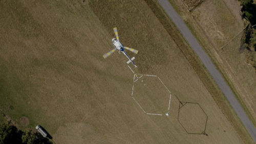
The state-of-the-art airborne electromagnetic technology survey (known as SkyTEM), captured raw data across 8000-line kilometres of flightlines, to an average depth of 300 metres.
Hawke’s Bay Regional Council Team Leader - Hydrology and Groundwater Science, Simon Harper says the technology greatly improves understanding about how the aquifers work.
“We expect that businesses and the public will benefit from this comprehensive dataset now that it is available. How it is used and the benefits going forward will no doubt evolve as our technical and scientific communities build on this work,” says Mr Harper.
“The new models will help the Council make better policy and rules to balance the water demands of industry and agriculture, while not adversely impacting the health of our aquifers.”
GNS Science Senior Hydro-Geophysicist Zara Rawlinson says that the level of 3D detail provided by the data has exceeded expectations.
“This high-resolution spatial detail, combined with existing borehole data such as the age of groundwater, has significantly improved our understanding of the region’s aquifer systems. This is vital information to support the sustainable management of Hawke’s Bay’s freshwater.”
“Hawke’s Bay was the first regional council in the country to map its aquifers using SkyTEM. Building on this innovative work for NZ, GNS Science has partnered with other organisations to undertake similar work programmes in Northland, Wellington, Gisborne and Southland.”
General Manager Regions for Kānoa – RD, Kay Read says, “It’s fantastic to see this significant mapping work completed and available for public use. By gaining detailed insights into our water resources, the region can better improve its resilience to droughts and support economic productivity. PGF support for HBRC’s overarching Regional Water Security programme totals around $40m, including $2m for this SkyTEM Survey. I look forward to the completion of the further water storage projects in the programme.”
Funding for the SkyTEM Survey included $2.4 million from Hawke’s Bay Regional Council, $300 000 from GNS Science, and $2 million from the Provincial Growth Fund (PGF) administered by Kānoa – RD. ”This is a great example of local and central government agencies working together to support a critical project in the region,” says Mrs Read.
The aerial surveys, undertaken by helicopter in the summer of 2020, flew over the Heretaunga Plains and offshore area, the Ngaruroro River Valley, the Poukawa / Otane catchments, and Ruataniwha Plains.
To find out more about the story of the project and use visualisation tools, go to the online story map.
END
Need more info?
HBRC Communications Advisor – Brendon Lane | 027 320 3523
Kanoa, MBIE | Kanoacomms@mbie.govt.nz
GNS Science media team | media@gns.cri.nz | 021 574 541
Contact us
+64 6 835 9200
159 Dalton Street. Napier 4110
Private Bag 6006, Napier 4142
Disclaimers, Copyright & Privacy
![]()
Disclaimers and Copyright
While every endeavour has been taken by the Hawke's Bay Regional Council to ensure that the information on this website is
accurate and up to date, Hawke's Bay Regional Council shall not be liable for any loss suffered through the use, directly or indirectly, of information on this website. Information contained has been assembled in good faith.
Some of the information available in this site is from the New Zealand Public domain and supplied by relevant
government agencies. Hawke's Bay Regional Council cannot accept any liability for its accuracy or content.
Portions of the information and material on this site, including data, pages, documents, online
graphics and images are protected by copyright, unless specifically notified to the contrary. Externally sourced
information or material is copyright to the respective provider.
© Hawke's Bay Regional Council - www.hbrc.govt.nz / +64 6 835 9200 / info@hbrc.govt.nz