I want to...
Current filter: Most popular
A to Z
Apply for a job
Biosecurity
Consents
Consultation
Contact Us
Environmental Data
Farmers Hub
Fix it or Report it
Information Request
Join an Event
Leasehold Land
Meetings
Rates
Water Metering
Have Your Say
Completed LiDAR project enhances understanding
Published: 13 September 2024
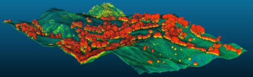
Hawke’s Bay Regional Council, in collaboration with researchers from Manaaki Whenua, have completed a pioneering project using LiDAR (Light Detection and Ranging) technology to gain a deeper understanding of the region's landscape.
This project uses LiDAR to create high-resolution maps detailing land and vegetation across the region, providing an unprecedented level of detail on the region’s topography.
The newly developed digital elevation models (DEMs) enhance the accuracy of assessments for erosion, sediment loads in rivers, and overall landscape changes. With slope data now available at five-meter intervals (compared to the previous 25-meter intervals), these advancements significantly improve land use capability assessments.
Regional Council’s Senior Scientist Dr Ashton Eaves says, “The newly available LiDAR landscape layers represent a substantial leap forward in environmental and infrastructural planning for the region. The Regional Council will use the data to better manage erosion-prone land, update Land Use Capability (LUC) classes, and accurately identify priority biodiversity areas”.
Sam Carrick, Portfolio Leader at Manaaki Whenua notes: “This partnership really benefitted from staff of both organisations working together closely in the design and implementation of the projects. This enabled Regional Council staff to develop an in-depth understanding of our latest science advances, such as erosion modelling or the ability to map individual trees, and likewise Manaaki Whenua scientists were able to get a greater appreciation of Hawkes Bay needs and to develop tools that are directly applicable by council”.
The new LiDAR data, based on 2020 readings, is also now accessible to the public through Geographic Information Systems (GIS).
To learn more about LiDAR technology, visit www.hbrc.govt.nz and search #lidar. For more information on accessing the new LiDAR layers and their potential uses, please contact GISsupport@hbrc.govt.nz.
Further information
- LiDAR, which stands for Light Detection and Ranging, involves precise laser measurements of the Earth's surface. This technology allows for the creation of highly accurate 3D maps of land and its features. The new LiDAR data will be instrumental for councils and various sectors by providing detailed insights into topography and the built environment.
- Hawke’s Bay Regional Council, in collaboration with Central Hawke’s Bay District Council, Hastings District Council, Napier City Council, and Wairoa District Council, secured $14 million from the Provincial Growth Fund to support this project. Additionally, Manaaki Whenua Landcare Research NZ has matched an extra $500,000 contribution from the Hawke’s Bay Regional Council, enabling further development of modelling and reports derived from the LiDAR data.
- The aerial survey data collection began in March 2020 and concluded in May of the same year. Despite challenges posed by the COVID-19 pandemic and extreme weather events, which led to some project delays, the data processing was completed, and the final results were delivered in June 2024. This research significantly enhances regional resilience to extreme weather conditions.
Media contacts
- HBRC Communications Advisor Brendon Lane | Phone 027 320 3523
- Manaaki Whenua - Landcare Research Principal Communications Advisor Dan Park | 022 411 5095
Contact us
+64 6 835 9200
159 Dalton Street. Napier 4110
Private Bag 6006, Napier 4142
Disclaimers, Copyright & Privacy
![]()
Disclaimers and Copyright
While every endeavour has been taken by the Hawke's Bay Regional Council to ensure that the information on this website is
accurate and up to date, Hawke's Bay Regional Council shall not be liable for any loss suffered through the use, directly or indirectly, of information on this website. Information contained has been assembled in good faith.
Some of the information available in this site is from the New Zealand Public domain and supplied by relevant
government agencies. Hawke's Bay Regional Council cannot accept any liability for its accuracy or content.
Portions of the information and material on this site, including data, pages, documents, online
graphics and images are protected by copyright, unless specifically notified to the contrary. Externally sourced
information or material is copyright to the respective provider.
© Hawke's Bay Regional Council - www.hbrc.govt.nz / +64 6 835 9200 / info@hbrc.govt.nz