Current filter:

FORTY water take bans are now in effect across Hawke’s Bay and the region desperately needs forecast rain.
The Waipawa River came under a total ban on Sunday 5 February, while Ngaruroro River at Fernhill will be in total ban as of 5pm on Tuesday 7 February.
A southerly change due on Tuesday afternoon should bring rainfall, according to MetService, in the headwaters of the Bay’s main ranges.
While short-lived, any rainfall will be a welcome respite to very dry ground and potentially bolster the region’s rivers before the sun returns on Friday.
Hawke’s Bay Regional Council’s water gauging team will be busy re-gauging river flows later this week based on rainfall, manual gauging at key sites and automated data feeds.
A quick view map plus up to date details are on http://www.hbrc.govt.nz/services/water/low-flows/ – or search hbrc.govt.nz, keyword: #lowflows.
Total bans currently operating as at 7 February
Kauhauroa Stream, Kopuawhara Stream, Waimaunu Stream, Sandy Creek/Papakiri Stream at Tūtira, Aropaoanui River, Ngaruroro River at Whanawhana and Fernhill (from 5pm 7 Feb), Karamū Stream, Patirua Stream, Mangateretere Stream, Louisa Stream, Karewarewa Stream, Te Waikaha Stream, Poukawa Stream, Waipawa River, Tukipo River, Papanui Stream and Puhokio Stream.
Partial bans operating as of 7 February
Tutaekuri River at Puketapu (for 3,800 litres/second), Tutaekuri-Waimate Stream (down to 1890 l/s), Raupare Drain (down to 549 l/s), Maraekakaho Stream (down to 250 l/s), Tukituki River at Red Bridge (down to 22,022 l/s) and at Tapairu Road (down to 3000 l/s).
During a ban, consent holders are not able to take water for crops or pasture, but are able to take water for domestic and stock supply.
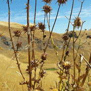
Photo credit: Sarah Cates - parched weeds and grass on the slopes of Te Mata Peak.
7 February 2017
Disclaimers and Copyright
While every endeavour has been taken by the Hawke's Bay Regional Council to ensure that the information on this website is
accurate and up to date, Hawke's Bay Regional Council shall not be liable for any loss suffered through the use, directly or indirectly, of information on this website. Information contained has been assembled in good faith.
Some of the information available in this site is from the New Zealand Public domain and supplied by relevant
government agencies. Hawke's Bay Regional Council cannot accept any liability for its accuracy or content.
Portions of the information and material on this site, including data, pages, documents, online
graphics and images are protected by copyright, unless specifically notified to the contrary. Externally sourced
information or material is copyright to the respective provider.
© Hawke's Bay Regional Council - www.hbrc.govt.nz / +64 6 835 9200 / info@hbrc.govt.nz